Description
NAVIGATE YOUR WORLD WITH TOTAL CONFIDENCE
Kimap 4.0 is the ultimate companion for accessible travel, designed to help you move freely and discover inclusive spaces. You have the power to map locations and provide accessibility information. Every user counts!
MEET YOUR AI ACCESSIBILITY ASSISTANT
Kimap 4.0 introduces a smart AI assistant ready to help you 24/7. Ask about specific locations, terrain, or facilities. It gives you the details you need to plan your trip without surprises.
PATENTED NAVIGATION FOR EVERYONE
We're the first and only navigator built for motor-disabled individuals. Our patented technology calculates the best possible route for you. Move through your city with a system that understands your needs.
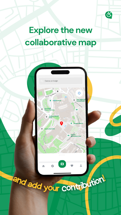
REDESIGNED MAP & ADVANCED FILTERS
Finding accessible spots is now easier. Our new map is cleaner and faster. Use advanced filters to find restaurants, shops, and services that meet your specific requirements. No more guessing.
JOIN THE COMMUNITY & EARN REWARDS
Every user makes a difference. Share photos and reviews to help the community. You'll earn points, unlock badges, and win prizes as you contribute. Climb the rankings and become a top Kimapper.
EXPERT TRAVEL GUIDES
Discover curated guides created with local associations and experts. From city tours to hidden gems, we show you the best accessible destinations. Barriers won't stop you from having unique experiences.
Why Kimap?
* Patented Tech: The only navigator recognized for motor-disabled routing.
* AI-Powered: Instant answers to your accessibility questions.
* Community Driven: Real-time updates from people who care.
* Gamified Experience: Earn rewards while making an impact.
Download Kimap today and join the movement. Together, we're mapping a world without limits!
Nouveautés (v4.1.0)
=========================================
KIMAP 4.1 - RELEASE NOTES
=========================================
We're excited to introduce KIMAP 4.1! In this major update we've added new features designed to make the city mapping and exploration experience even more inclusive, precise, and fast.
Here are all the details of the new features:
VIDEO UPLOAD SUPPORT
• Show the city in real time: record and attach short videos to document the accessibility status of places and barriers.
• Data optimization: we've set a maximum file size limit to ensure lightning-fast uploads and save your mobile data while on the go.
NEW ARCHITECTURAL BARRIER CATEGORIES
• Targeted reporting: added dedicated guided flows for potholes, uneven pavement, steps, missing ramps, and narrow sidewalks.
• Dedicated map icons: all barriers are now identified on the map with custom icons for immediate visibility.
DYNAMIC FILTERS AND FAVORITES SLIDER
• Clean search: filters adapt to you! View only place types when exploring locations, or only barrier types when looking for obstacles.
• Independent Favorites slider: toggle your favorite places on or off with a single tap on any selected category.
NEW PARKING CATEGORY
• Accessible parking: added the "Parking" category with its own exclusive map icon for quick location.
• Space reporting: directly indicate whether a parking spot is compliant or not accessible to help the entire community in their daily searches.
HIGH READABILITY FONT (OPENDYSLEXIC)
• Digital inclusion at the core: enable the "OpenDyslexic" font display directly from your profile settings to make reading texts and map descriptions much easier and more comfortable.
NEW ENHANCED AI ASSISTANT
• Fast responses: migration of the integrated chatbot to the new native artificial intelligence engine for fast responses and unprecedented stability.
• Virtual itineraries: the assistant now supports you in planning accessible virtual itineraries based directly on map data.
• Accurate and verified responses: improved chatbot response accuracy, with the integration of precise citations to official sources to eliminate any informational ambiguity.
OPTIMIZATION AND BUG FIXES
• Safe Area management: added native support for mobile devices to prevent visual overlaps with notches and system bars.
• Mapper Form: fixed graphical issues with Dark Theme, ensuring that element selection is always visible and readable.
• User Profile: fixed a bug in saving the personal Bio and improved stability in loading profile data.
• Layout fixes: resolved a visual overlap issue where a place name could end up under the favorites icon.
• Guide Exploration: optimized automatic population of information related to existing points of interest within guides.
• Caching and Smoothness: enhanced local photo caching and resolved sporadic crashes during heavy media file loading, making the map smooth in every condition.
=========================================
Thank you as always for your valuable contribution in making our cities increasingly accessible and barrier-free!
=========================================