Description
Saudi Arabia's public transit, beautifully mapped.
MetroSaudi is a free, elegant app that brings together the maps and stations of the Kingdom's most important rail networks: Riyadh Metro, Mashaaer Metro, and Haramain High-Speed Rail — all in one Arabic-first, ad-light, privacy-respecting experience.
What makes it stand out:
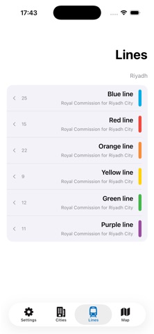
• Interactive map: All 6 Riyadh Metro lines, plus Mashaaer and Haramain stations, drawn with precision and official colors.
• Journey planner: Pick your start and destination — get the best route with transfers, station count, and estimated time.
• Nearest station: Instantly see the closest station to your current location, with walking distance in meters.
• Smart search: Find any place or landmark and we'll show the nearest metro station to it.
• Service hours: Know exactly when each network operates — including Hajj-only service for Mashaaer.
• Full Arabic experience: Designed RTL natively, with one-tap English toggle.
• Light & fast: No login, no clutter, minimal data collection.
Supported networks:
• Riyadh Metro — All 6 lines (Blue, Red, Purple, Yellow, Green, Orange) with every station.
• Mashaaer Metro — Mina, Muzdalifah, Arafat (operates during Hajj season only).
• Haramain High-Speed Rail — Makkah, Jeddah, Rabigh, and Madinah.
• Riyadh Buses — Major routes and stops.
Built for Saudi Arabia:
This is an unofficial app, not affiliated with any government body or operator. It's built on publicly available data and designed to give Arabic-speaking users the smoothest, cleanest experience possible.
Privacy-first:
We don't collect your personal data. Your location is used locally on your device only, to find the nearest station. No tracking ads, no third-party data sharing.
Download now and discover Saudi metro like never before.
Support: support@metrosaudi.app